Atene Skyline Walk
Atene Skyline is a challenging yet accessible track offering history and views into parts of the Whanganui National Park otherwise unseen.
Beginning from the northern entrance the track offers two options.
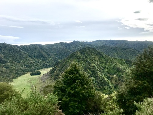
Atene Viewpoint walk. An out-and-back walk to a viewpoint above the former riverbed of the Whanganui River. Now green pastureland, the viewpoint allows the mind to wander as you imagine the river flowing around Puketapu Hill. After an initial steep climb, the track follows the route of a benched road, originally bulldozed by the ministry of works as part of a proposed hydroelectric scheme on the Whanganui River. The scheme never eventuated.
Atene Skyline Track: Continuing on from the viewpoint the track undulates along a series of ridges on a formed track. Some sections are steep and require a reasonable level of fitness. Points of interest include views out over the AhuAhu Valley ahead of reaching the shelter. From here the track climbs to the Taumata Trig 572m, and sidles around sandstone bluffs to the Taupiri trig ahead of the descent to the road. A 2 kilometre walk along the roadside is required to make this a full loop.
Wildlife: On our visit we encountered birds including Tui, Fantail, Kereru, and Tomtit. The area is also inhabited by wild goats which may be spotted in the distance on the tracks.
Getting there:
The track begins approx. 36km from Whanganui, located on the Whanganui River Rd just north of the settlement of Atene (London). Be sure to stop at the Aramoana lookout on your drive to the start and admire the view of the Whanganui River as it winds its way through the misty valley.
Wildlife: 1/2
Scenic: 1/2
History / Points of interest: 1
Quiet / Relaxed: 1
Visit again: 1
Smiles per Hour rating: 4