Through The Hills
Unstable tunnels, muddy bog holes and hills so great the only way is through.
Isolated and unsupported. Two characteristics my bikepacking journey shares with those who failed to tame these lands almost a century ago.
The 10-day forecast was finally predicting the fate of my trip, 70mm of rain in 4 days. Having spent much of my bikepacking saddle time in the Taranaki Hills, I could see this trip being washed away right before my eyes. Now, back to the calendar to align the cosmic ducks of work, life and family. Before long, another weekend was on the horizon. Fingers crossed and with a half-hearted commitment, I looked at the forecast. It had not been a balmy summer since I last looked, but a short spell of clear days was the ray of sunshine I needed. Literally!
Not the week of fine weather I asked for, but I was not about to look this gift horse in the mouth.
Etched in my mind, the words of New Zealand’s mountain biking forefathers, The Kennett Brothers, about the Bridge to Somewhere, via Whangamomoana Rd, “Best ridden after a week of fine weather”. Combined with previous experience, this wisdom left me a little anxious.
I find myself in the republic of Whangamomoana just after 8.30 am on a Saturday in early October. Attaching my bags to my bike, I double-checked my worldly possessions before setting off into the first valley time forgot.
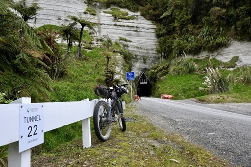
Unsafe roads and deadly bridges. Or so the sign says. Some 80 years ago, the local council ceased to maintain the road. With government support unreliable, the pioneering WW1 servicemen, once gifted the land to farm in recognition of their service, found themselves with little choice but to forfeit it to mother nature.
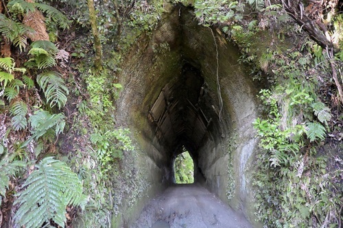
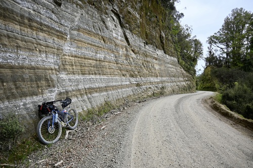
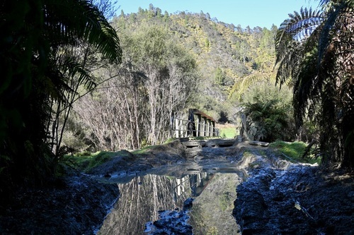
Six kilometres in, I enter a gothic arched tunnel in the bush-clad spur above the Whangamomona river. As I exit, I breathe a sigh of relief. A slip I previously encountered is not the issue I had convinced myself it could be. The clear path offers an unobstructed view of another tunnel just 50 metres away. The semi-arched cavity casts a beam of mid-morning sunlight upon one of the infamous Papa mud bogs.
My worst-case scenario was not even a scenario.
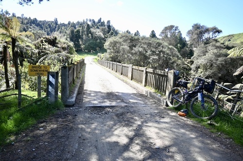
After almost 3 hours, I approach the last gate. It leads to a gravel road and a Bridge; To Somewhere. Atouhia Station, to be precise. Constructed in 1937, it gained its name in the 1980s when the Department of Lands and Survey opened the abandoned valley for resettlement. The bridge from then on leads somewhere. Ironically, onto private land.
Day 2: Following a well-earned night of rest in Stratford and a re-supply at the local 4Square, it was time to hit the road. Blessed with a calm morning and small hills, I soon find myself approaching the Kiore tunnel, also known as the Matau, after the village north of the tunnel. It seems Taranaki people are patriotic about their tunnels.
Upon exiting the tunnel, the road becomes remote and winding, bordered by mature pine forest, the roadside decorated with pine needles, lush green grass banks and tree ferns thriving in the sheltered valley ahead of a short climb to the Purangi Junction. Time for a quick boil of the billy before following the Forgotten World Cycle trail towards Taranaki’s most original tunnel. Arguably the most picturesque, the Tarata or Otaraora Rd tunnel has been spared modifications since its construction in 1904.
It is not long before my destination for today appears on the horizon. I soon find myself relaxing at Urenui Beach, surrounded by the beauty of towering white cliffs illuminated by the soft light of the sun now low in the sky.
Day 3: Inevitably, the forecast has taken a turn. Rain is now on the horizon. I wash down some oats with coffee, on the road by 7 am.
Four days ago, I received the news via the bikepacking community that the Uruti Tunnel is making headlines for all the wrong reasons. “Uruti tunnel still closed after August’s torrential rainfall.”
A detour along State highway 3 is less than ideal. Unpleasant but necessary.
Confusion is a constant companion as I climb to the summit of Moki road, reaching what is commonly known as the Western Kiwi Road tunnel. In a twist of irony, it is located 1 km before the intersection of Moki and Kiwi roads, a famous piece of Taranaki road that almost nobody uses. “Caution! Not suitable for caravans or heavy vehicles”, another ominous sign about Taranaki’s casual relationship to its back country roads.
The climb is tough, tar seal sections on a gravel road tough. Its use is so infrequent three sets of closed gates divide the 13km stretch to the tunnel while stock grazes the road.
Kiwi Road made headlines in 2018 for being one of the most expensive roads in Taranaki to maintain. An annual burden of $40,000 for an average of ten cars per day. Upon exiting the tunnel, grass grows down the middle and goats race ahead for the 6-kilometre descent.
Okau road brings back a sense of civilisation momentarily. Tar seal, white lines and two lanes. I follow this with the same novelty of the yellow brick road, for I am off to see one of the more unique tunnels. Positioned on a curve in the Tongaporutu river, the Ahititi or Okau Tunnel, opened in the early 1930s, features bridges at both portals.
It's not far until I'm back to gravel roads and the longest climb of the route, 414m of vertical elevation in a little over 9 kilometres. An hour later and good is a feeling that is soon behind me as I reach the top of the Waitaanga saddle. Time for a rest and refuel before the last few ascents of the day.
After 115kms on the bike, a mossy sign welcomes me to the town the Forgotten World Highway forgot, Ohura. Even in the face of adversity, its quirky charm remains.
Day4: Just before 6 am, I routinely check the forecast. It’s inevitable I will get wet, but when.
I say goodbye to Ohura, or is that see you soon? This tiny King Country village is graced with so many nearby gravel roads to explore that I know I will be here again soon.
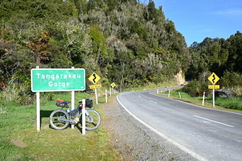
As the sun comes up behind me, I crest the Paparata saddle and descend towards New Zealand's last remaining section of unsealed state highway. The winding gravel road follows the river through the bush-clad Tangarakau Gorge to Morgans Grave. A rest stop and final resting place of Joshua Morgan, the pioneering surveyor of the Forgotten World Highway.
With the weather holding out, I break for a coffee and carbs to propel me towards the longest, most famous and last tunnel of the route, where the confusion continues. The Moki tunnel, atop the Moki range, is not to be confused with the Eastern Kiwi Rd tunnel on Moki road. Fortunately, a cheeky traveller bestowed the name the hobbit hole upon it, and it stuck.
Another fast descent reunites me with the Stratford-Ohakurua line as a sign, "Welcome to Tahora, you’re lost", announces my passing through yet another of the forgotten settlements.
I traverse one last saddle as the rail disappears through the hill below, reappearing in the valley, Zig- zagging across my path as I make my way back to the Republic of Whangamomona in a race against the misty rain.
As I pass the grave of Alice King, I start some mental arithmetic. A Bridge to Somewhere + 11 tunnels, divided by 350kms = a burger at the Whanga Hotel.
Feel free to double-check my maths, but I have confidence you too will conclude that, boasting a route that reveals a hand-dug tunnel every 32kms on average, Taranaki, no matter where the electoral boundaries lay, is like no other.
In 1989, regional boundaries were re-drawn. Whangamomona (meaning fat valley in Maori) officially became part of the Manawatu/Whanganui region. In protest, the residents of this proud Taranaki settlement declared Whangamomona a republic on 1st November 1989.
Accommodation and re-supply:
Whangamomona:
What Whangamomona lacks in re-supply options, it makes up for as the ideal start-finish point with food, a cold beverage and accommodation available at the Whangamomona Hotel: 06 762 5823
Alternatively, campsites are available at the Whangamomona Camp Ground: 06 762 5881
Stratford:
The largest town on the route, Stratford has a supermarket and 4 square.
Stay at the bike-friendly Stratford Motel and Holiday Park: 06 765 6440
Urenui:
Urenui 4 square has a wide range to keep you fueled back to Whangamona, with a local fish and chip shop a short ride away from an evening of fish and chips on the beach at Urenui beach camp: 06 752 3838
Ohura:
Ohura is home to the finest Mexican hospitality. Be sure to pre-arrange your dinner with Michelle, owner of Fiesta Fare and Ohura B &B when you book your accommodation.
Alternatively, ensure you’re prepared to cook for yourself, as Ohura has no re-supply options.
Ohura B & B: Michelle 022 0800848
Route Information: Through The Hills on RideWith GPS
Find the YouTube feature here.