Tunnels of Taranaki
Note: These tunnels are in the order they were reached on, "Through The Hills", with additional tunnels listed below. Read the article.
This list is incomplete, although regularly updated as more tunnels are visited and explored. Be sure to check back soon or join me on buy me a coffee for the latest updates.
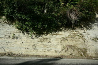
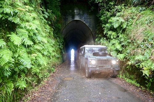
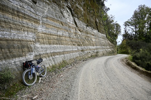
Whangamomona Road #1
The road and bridges have been unmaintained by the District Council for over 80 years, with maintenance funded by four-wheel drive clubs via a jar at the Whangamomona pub.
The first of two tunnels on a spur near the Arnold Stream on the Whangamomona Road.
Access is by 4 wheel drive, on foot or motorbike.
ALWAYS CHECK LOCAL INFORMATION FOR ACCESSIBILITY
Tunnel # 1 is about 6 kilometres from Whangamomona. Approximately 40 metres in length it features a typical Gothic arch profile. The pick marks of the excavators remain visible on the tunnel walls.
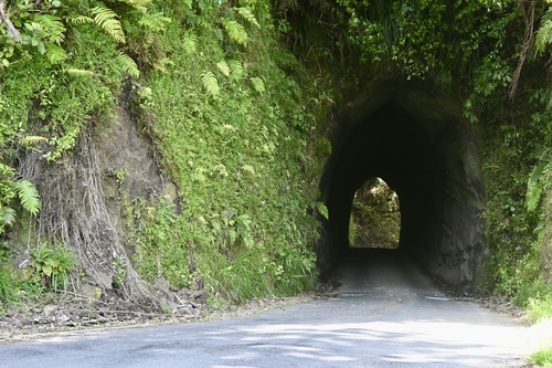
Whangamomona Road #2
Situated a few hundred metres from the # 1 tunnel on Whangamomona Rd, near the Arnold Stream is Tunnel #2. A mere 20 metres in length, it is unusual as it is one of two Taranaki road tunnels to have a semi-circular profile. (The other is the Aukopae Tunnel. Technically in the King Country, it is on The Forgotten World Highway.)
Huinga
Built to provide access to the end of Raupuha Road, the Huinga tunnel is Taranaki’s oldest. The drive was completed in 1893, and its completion was marked with a plaque set into the wall "Fitzgerald Aug. '(18)95".
Further information thanks to Puke Ariki:
Not much is known about the actual building of this tunnel, although originally the roof and part of the lining were made of native timber; the sides being solid papa. A very unusual feature was the large scrim timber doors at one end, used to try and control the draught.
After 30 years, the moisture inside the tunnel confirmed its degrading effect on the wood, with most of the south roof rotting through. During repair attempts, the tunnel collapsed crushing two repair trucks.
The tunnel roof was lowered following major repairs, but by 1936 the roof was again raised, with the inclusion of hardwood posts and railway iron arches. These posts were quite dangerous - two years later a local boy caught his leg on one of them, resulting in boards being put across them for safety.
Huinga tunnel has almost always had a problem with Earth and Papa falling inside it. In 1944, there was a particularly bad slip, and a New Plymouth firm was contracted to fix it. They mixed the concrete on the tunnel floor and had a worker shovel it onto a platform and plaster it onto the roof with his shovel. By 1958, the southern end of the tunnel was gunited (spray concrete coated) and declared safe.
In February 1971, however, slips after heavy rain blocked the tunnel and caused slips again to the south end, making it impassable. These were fixed but made people question the necessity of the tunnel, as it was costing a large amount to keep standing.
In 1997 the tunnel floor was lowered to ease access by large vehicles and stock trucks
The tunnel floor was concreted in 2010. In December 2012 locals and former residents held a party to celebrate the tunnel.
Getting there: As Ruapuha Rd doesn't appear on Google, directions are as follows. (All other tunnels are easily locatable).
Headed from Stratford on Highway 43, Turn right into Toko Rd at Toko. Follow this for approx 5 kilometres before turning right into Ruapuha Rd. The Huinga tunnel is approx a further 5 kilometres along Ruapuha Rd. Ruapuha Rd is not a through road and will require a back track. The road gravel, narrow and windy after the tunnel.
Makahu

Words by Puke Ariki: Constructed in 1907. The timber lining had decayed by 1919 and was replaced by the present concrete pillars. In a major upgrade in 1998, the floor was lowered to allow stock trucks to access Makahu through the tunnel.
The following text is from the Stratford District Council Heritage Register:
A pack track was all that originally joined Strathmore and Makahu, a community that was settled in 1896. By 1902, a dray road was completed to replace this, but it was harsh, and the route over the hill was seen as a formidable obstacle. The erection of the Makahu Co-operative Dairy Factory a few years later embellished the need for a better access route for the product to be able to be easily carried out.
In 1907, this was dealt with the building and opening of the Makahu (or Brewer Road) Tunnel. The settlers worked hard, making full use of picks, shovels, wheelbarrows and explosives to eliminate the steep grade. People protested that the tunnel had been built too near the top of the hill to be at all worthwhile. However, the 166-metre tunnel made the journey more than 3km shorter and saved travellers from battling the windy hill route.
The tunnel was originally made out of an interesting construction of wood, with a timber lining. However, by 1919 the wood had rotted through and the tunnel collapsed at the Makahu end. It was closed for two years while work was done to re-line the tunnel with more solid concrete pillars to ensure no further cave-ins were possible.
Throughout the years, the locals have held numerous impromptu "parties" inside the tunnel, which occasionally forces travellers to join in or wait until the end to get through.
Observing the Makahu tunnel today, one would be able to see where the floor was lowered and would note the small orange stalactites dropping from the ceiling. The tunnel is perhaps one of the most attractive tunnels in Taranaki, being strong-walled and perfectly shaped. It is a great feature on this rural road and is well worth the journey to see it.
In 1998 a major upgrade of the tunnel was carried out by contractor Mc Mackenzie and his team. This had a total cost of $500,000 and included lowering the tunnel floor by 1.4 metres to give triple-deck stock trucks access to the road, installing new support struts, and strengthening the tunnel soffit with 150mm of reinforced concrete.
The upgrade took a total of four months and was reopened with a ribbon being cut by locals Jim Hopkirk and Danica Wood (who were descendants of settlers who protested the delay in fixing the tunnel in 1920) on 22 July 1998.
Today, the tunnel acts as an access point to the Makahu and Puniwhakau communities, the Te Wera Forest, Aotuhia Station, the "Bridge to Somewhere" and a large proportion of the Whanganui National Park, including the Matemateaonga Walkway.
Kiore (Matau)

Words by Puke Ariki:
The Matau, Junction, Mangaoapa and Mangamaire Roads were originally located in Clifton County, with the surveying being finished in 1893. The land was steep, and progress was held back by limited funds and difficult communication. Some settlers battled on, and Matau became one of two villages that met these settlers' basic needs. A school was opened in 1896 with a roll of 10 pupils; a post office and a small store were added, and farmers made butter in their dairies as the road was too poor to be able to establish a dairy factory.
Before the early 1900s, the main route to this village was via Purangi and Tarata. However, the inland railway advanced and a railway line from Stratford to Ongarue was started in 1905. The settlers of Matau decided that because of this, the road over the saddle to Kiore needed to be completed. Slow progress meant that by 1908 the railway had gone as far as Huiroa, but the road was still not complete. In fact, by this stage, the Kiore tunnel had only just begun to be dug out.
The Kiore Tunnel has many names, also known as the Matau Tunnel, the Matau Valley Tunnel, and the Mangaoapa Road Tunnel. No matter what it is called, however, it still stands and is still in use. It is perhaps one of the most treasured tunnels in Taranaki, as it is one of the few that still retains its original cross-section, and has had no widening or lowering take place.
In 1910, the completion of the tunnel marked the completion of the road to Kiore. This road became the main access to the village and surrounding farms. The ease of it compared to earlier access routes gave a new life to the area and greater value to the land. Settlers could now sell their land for profit if they wanted to move away, instead of having to just leave it.
By 1950, the tunnel started to show signs of decay, with the timber lining beginning to rot through and collapse. A Feilding firm was employed to take the old timber out and replace it with reinforced concrete. This was done to about three-quarters of the tunnel, with the original timber remaining to line the rest, and the total cost was ₤3,820. No further work was carried out on the tunnel until 1994, when the lining was replaced with rock bolts, reinforcing mesh and concrete.
(A major upgrade including rock bolts and shotcrete lining was completed
by contractor 'Mac' Mackenzie in 1994.)

The former Kiore dairy factory (or part of) is now siituated on Mohakau Rd, on the Kiore side of the tunnel. continuing its life as a roadside farm building, still emblazon with Kiore on its frontage.
Tarata/Otaraora Rd
Remaining largely unchanged since it was dug in 1904, the Tarata (Otaraoa Road) tunnel is the most original in Taranaki, still open to traffic.
At the time a Clifton County Engineer reported "that the tunnel on Otaraoa Road had been completed at £315.." (Taranaki Herald, 12 Oct 1904) (credit Puke Ariki)
In recent years, with large commercial vehicles wishing to use the tunnel, proposals for enlargement have been made.
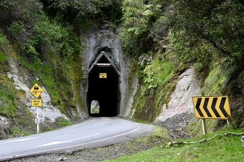
Uruti/ Kaka Road
Constructed on the Uruti (or Kaka Road) in 1916, being completed in 1923, the tunnel links the two roads through a steep ridge. It is sometimes known locally as the Tangitu tunnel after the stream below. Until its excavation, settlers at Pehu had access only from Stratford through Kiore. The tunnel is notoriously unstable, with closure having been proposed several times in the past. Most recently, in 2022, the tunnel was closed for a significant period causing great unrest among locals.
Ahititi/Okau
Arguably Taranaki’s most unique tunnel, the Ahititi/Okau tunnel sits in the middle of the Tongaporutu River, with bridges at both ends. Although details about its construction remain unknown, it is believed to have opened in late 1932 or early 1933.

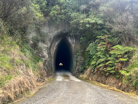
Moki Road
Commonly referred to as the Western Kiwi Road tunnel due to its proximity to Kiwi Road and to alleviate confusion with another tunnel on the Moki range (Ohura Rd, Tahora Saddle)
The western portal is picture-perfect with its gothic styling and bare rock face. No details are available about its construction or history.
A short distance from the Western Portal is a normal fault, a visible geological feature in the cliff face.

Kiwi Rd
Known as the Eastern Kiwi Road tunnel, completed in 1915, this is the only tunnel on Kiwi Rd. The confusion comes in from the Moki Rd tunnel, 1 kilometre from the intersection of Kiwi and Moki roads. The Kiwi Rd tunnel rose to fame in 2018 when the NPDC floated the intention cease maintenance of the road due to the cost. Read that article here.
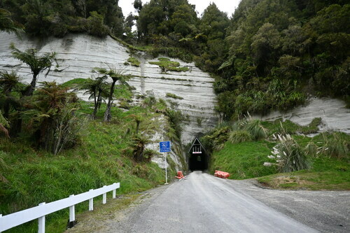
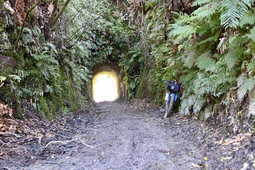
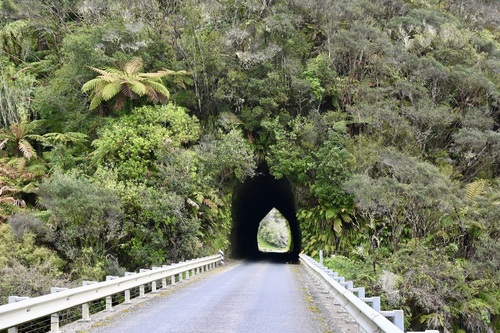
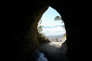
Moki/Tahora – The hobbit hole
The Moki Tunnel was one of five tunnels proposed by Joshua Morgan (a surveyor in Whangamomona) in the 1890s before his unfortunate death in 1893. Situated at the top of the Moki saddle, it has become known as the Moki Tunnel, as it sits atop the Moki range, causing considerable confusion with another Tunnel on Moki Rd, often known as the western Kiwi Rd tunnel. This tunnel was the only one of the five proposed and is only a few kilometres from Morgans Grave.
Further information thanks to Puke Ariki.
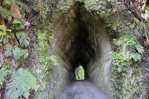
The tunnel was constructed in 1935-1936 by the Public Works Department after they had completed metalling the road. Mr Townley was the engineer, and Mr Birss the overseer. It was dug using two power jackhammers driven by a coal-fired steam compressor, which was situated at the western Tahora end of the tunnel. The coal was supplied from the Tangarakau Gorge mine and was brought to the site by Mr Ron McCartie, a Tahora settler. As the work on the tunnel continued, the coal-fired compressor was replaced with a diesel-powered air compressor, lessening the need for coal. While the tunnel was being dug, many unique fossils were found.
The spoil from the tunnel was carried out by horse and skip on steel rails that had been laid from the tunnel to the tip face, making the road wider on either side. The spoil was used to fill where the road presently runs, which has been broadened to a two-lane sealed road.
The tunnel is approximately 180 metres long and was originally built five metres high. However, with the introduction of stock trucks and trailers onto the road, this was not high enough. In 1985, Colin Boyd (from Inglewood Metal Supplies) lowered the floor a further two metres.
About two decades ago, a witty traveller nailed up a sign re-naming the Moki Tunnel as the "Hobbit Hole". This nickname is still used today. The Moki Tunnel is a fine example of the unusual and well-thought-out work completed by the road engineers and surveyors of early New Zealand. It has been appreciated by many travellers on the road and is seen as one of the remote tourist attractions of Taranaki.
Bonus Tunnels:
Aukopae
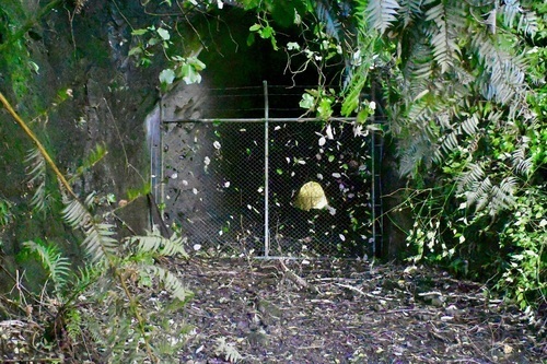
Situated in the tunnel hill scenic reserve, on the Forgotten World Highway between Aukopae and Tokarima is the Aukopae road tunnel.
Taking more than 10 years to complete, due in part to the wart effort and the hardness of the Papa rock, the Aukopae Tunnel was in service from around 1923 to 1960. Closed in 1960 because it was too small for modern trucks, the road realignment saw it become obsolete. Now accessed by a 40-minute (return) walk across farmland following the original road alignment, it is one of the few in original condition, with a dirt floor and original dimensions
Although the tunnel gained a second chance at life in the 1980s with a Local farmer using it to store hay, it is now fenced at both ends.
https://youtu.be/iFjldpoDrWw?t=552
Tangahoe Tunnel
The second longest of Tarnaki's tunnels, construction of the Tangahoe Tunnel on Tagnahoe Valley Roadbegan in 1926 and was completed six years later.
Like many of the Taranaki tunnels, the Tangahoe has a chequered history thanks to the region's unique geology. Significant maintenance in 1954 saw the application of shotcrete to the tunnel walls.
A roof collapse resulting from an earthquake in 1986 saw the tunnel closed for 12 years. During this time, a deep and unstable cutting beside the tunnel provided unreliable road access.
Further maintenance was undertaken in 2003 when cracks appeared in the shotcrete, and bulging in the walls was discovered.

Fraser Smith Road Tunnel
Located near Awakino, full details here.
Waikawau Stock Tunnel
Located between Awakino and Marokopa, provided access to a remote beach, details here.
Graylings Stock Tunnel (Tarata Rd Tunnel)
Due to its geography, backcountry Taranaki likely has more tunnels per kilometre of road than anywhere in New Zealand. Graylings Stock Tunnel, originally the Tarata Rd Tunnel, is located south of the summit rest area, approximately two metres above the road.
The unusual location of the portal arose from a change in road alignment many years ago.
The portal is partially backfilled and obscured by scrub, blending into the surroundings, while the other portal opens on private land.
Little other history is available about Graylings Stock Tunnel. While a point of interest for train (tunnel) spotters, there is not much to see for the average tourist.